


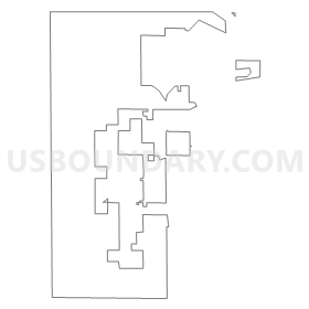
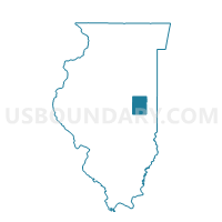
CHAMPAIGN 2 Voting District, Champaign County, Illinois
About
Outline
Summary
| Unique Area Identifier | 564771 |
| Name | CHAMPAIGN 2 Voting District |
| County | Champaign County |
| State | Illinois |
| Area (square miles) | 12.33 |
| Land Area (square miles) | 12.29 |
| Water Area (square miles) | 0.03 |
| % of Land Area | 99.74 |
| % of Water Area | 0.26 |
| Latitude of the Internal Point | 40.12051330 |
| Longtitude of the Internal Point | -88.33044180 |
Maps


Graphs
Select a template below for downloading or customizing gragh for CHAMPAIGN 2 Voting District, Champaign County, Illinois


Neighbors
Neighoring Voting District (by Name) Neighboring Voting District on the Map
- CHAMPAIGN 3 Voting District, Champaign County, IL
- CHAMPAIGN 4 Voting District, Champaign County, IL
- CITY OF CHAMPAIGN 10 Voting District, Champaign County, IL
- CITY OF CHAMPAIGN 17 Voting District, Champaign County, IL
- CITY OF CHAMPAIGN 18 Voting District, Champaign County, IL
- CITY OF CHAMPAIGN 25 Voting District, Champaign County, IL
- CITY OF CHAMPAIGN 30 Voting District, Champaign County, IL
- CITY OF CHAMPAIGN 34 Voting District, Champaign County, IL
- CITY OF CHAMPAIGN 35 Voting District, Champaign County, IL
- CITY OF CHAMPAIGN 36 Voting District, Champaign County, IL
- CITY OF CHAMPAIGN 37 Voting District, Champaign County, IL
- CITY OF CHAMPAIGN 38 Voting District, Champaign County, IL
- CITY OF CHAMPAIGN 9 Voting District, Champaign County, IL
- COLFAX Voting District, Champaign County, IL
- HENSLEY Voting District, Champaign County, IL
- MAHOMET 3 Voting District, Champaign County, IL
- SCOTT-BONDVILLE Voting District, Champaign County, IL
- TOLONO 2 Voting District, Champaign County, IL
Top 10 Neighboring County Subdivision (by Population) Neighboring County Subdivision on the Map
- Champaign City township, Champaign County, IL (81,055)
- Mahomet township, Champaign County, IL (12,623)
- Champaign township, Champaign County, IL (10,834)
- Tolono township, Champaign County, IL (5,270)
- Hensley township, Champaign County, IL (1,278)
- Scott township, Champaign County, IL (1,258)
- Colfax township, Champaign County, IL (266)
Top 10 Neighboring Place (by Population) Neighboring Place on the Map
Top 10 Neighboring Unified School District (by Population) Neighboring Unified School District on the Map
- Champaign Community Unit School District 4, IL (93,268)
- Mahomet-Seymour Community Unit School District 3, IL (14,300)
- Tolono Community Unit School District 7, IL (9,017)
Top 10 Neighboring State Legislative District Lower Chamber (by Population) Neighboring State Legislative District Lower Chamber on the Map
- State House District 103, IL (114,337)
- State House District 110, IL (110,024)
- State House District 105, IL (109,839)
Top 10 Neighboring State Legislative District Upper Chamber (by Population) Neighboring State Legislative District Upper Chamber on the Map
- State Senate District 53, IL (226,526)
- State Senate District 52, IL (219,424)
- State Senate District 55, IL (213,429)
Top 10 Neighboring 111th Congressional District (by Population) Neighboring 111th Congressional District on the Map
Top 10 Neighboring Census Tract (by Population) Neighboring Census Tract on the Map
- Census Tract 109, Champaign County, IL (9,302)
- Census Tract 12.01, Champaign County, IL (6,590)
- Census Tract 9.02, Champaign County, IL (5,786)
- Census Tract 12.05, Champaign County, IL (5,037)
- Census Tract 9.01, Champaign County, IL (4,867)
- Census Tract 8, Champaign County, IL (4,844)
- Census Tract 12.03, Champaign County, IL (4,592)
- Census Tract 10, Champaign County, IL (4,510)
- Census Tract 12.04, Champaign County, IL (3,622)
- Census Tract 106.04, Champaign County, IL (3,151)